For more information about these projects, contact me.
Jump to:
- Upper Plate Deformation in the Kaikoura Earthquake
- Quantifying Geodynamic Forces
- Locking Mechanics and Pseudo-coupling
- Earthquake Cycle Stress Evolution
- Seismotectonics of Southeast Asia
- Great Earthquakes in the Chilean Subduction Zone
- Canterbury, New Zealand, Earthquakes
Upper Plate Deformation in the Kaikoura Earthquake
Collaborators: Kevin Furlong (Penn State University), Harley Benz (USGS), Kirsty McKenzie (North Carolina)
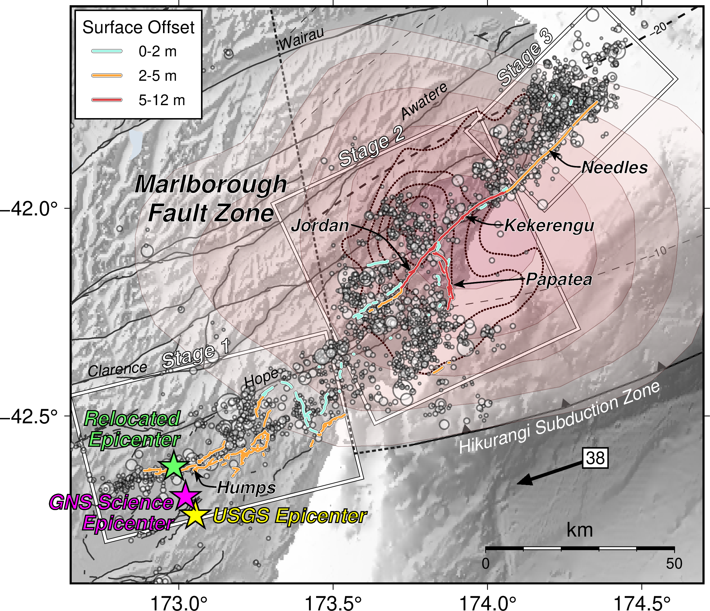 A magnitude 7.8 earthquake struck near Kaikoura Peninsula in New Zealand on November 13, 2016. This event broke at least 20 faults at the surface, making it one of the most complex events ever seen. Some of the faults shifted the ground by over 10 meters, more than nearly any other similar style earthquake of this magnitude. Intriguingly, although the earthquake began within the Pacific Plate, the extreme faulting only occurred after the earthquake rupture crossed into the Hikurangi subduction zone.
We developed deformation models of the earthquake showing how a subduction zone earthquake occurring on a shallowly dipping plate interface detachment beneath shallow surface faults explains these observations (Herman et al., 2023). The 2016 earthquake began as an intraplate strike-slip event within the Pacific plate, before triggering slip along the southern Hikurangi plate boundary. Slip on the plate boundary both triggered the surface faults and disconnected them from the rest of the Earth, allowing the ground to blow apart almost completely, experiencing near-complete strain release. This setting (specifically, the region above a subduction zone earthquake) is usually underwater. In contrast, the Kaikoura earthquake occurred in a setting where the usually offshore upper plate action was directly visible onshore. It is likely that these processes are acting at many subduction zones globally, but are invisible because they occur underwater.
Pseudo-coupling and Subduction Earthquakes
Collaborators: Kevin Furlong (Penn State University), Rob Govers (Utrecht University)
 An important component of evaluating earthquake hazards is measuring the rate of slip deficit accumulation on plate boundary faults. Where plates are frictionally locked on parts of the interface, the interface accumulates slip deficit at the rate of relative motion between the plates. These regions ("asperities") are where earthquakes typically nucleate and rupture. Outside asperities, although the interface might be able to slide at lower friction, proximity to locked areas prevents these regions from sliding at the full plate rate. These regions accumulate slip deficit, but at a lower rate than the relative plate motion rate, thus appearing partially locked despite no actual mechanical coupling across the interface.
 This framework for modeling inter-seismic slip deficit accumulation and areas of partial slip deficit may help to explain several observations of recent earthquakes. Ruptures that propagate outside of fully locked areas through these "pseudo-coupled" regions can be larger than expected from the asperity dimensions alone. Earthquakes also show an intriguing pattern of slip increasing along with rupture length. Our models explain this observation as the magnitude of slip being limited by the pseudo-coupling produced by neighboring, unruptured asperities. Finally, our modeled deformation around pseudo-coupled regions up-dip of locked asperities in subduction zones are consistent with observed patterns of tsunamigenic slip, such as those that were gathered after the 2011 Tohoku earthquake (Herman et al., 2018).
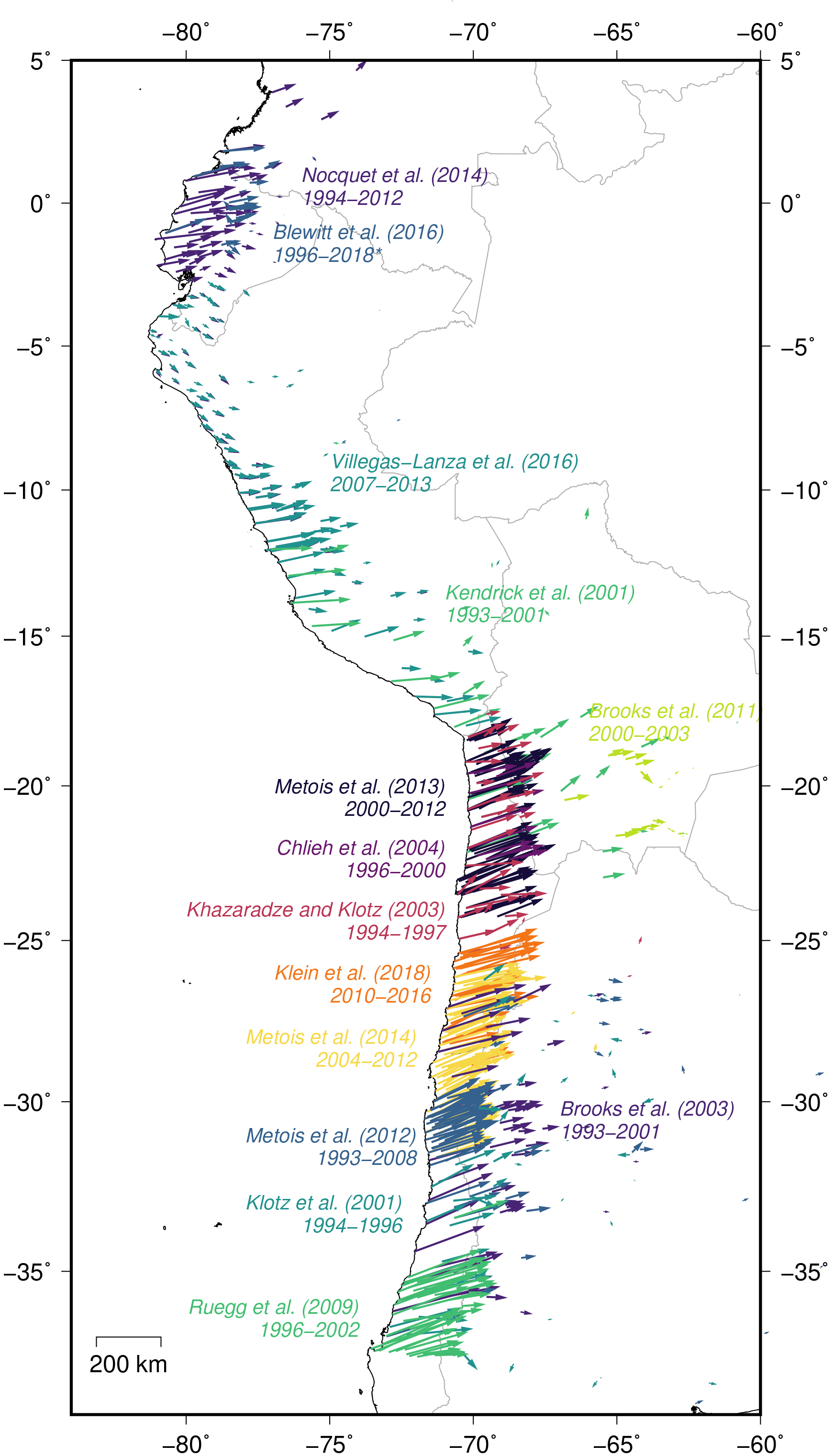
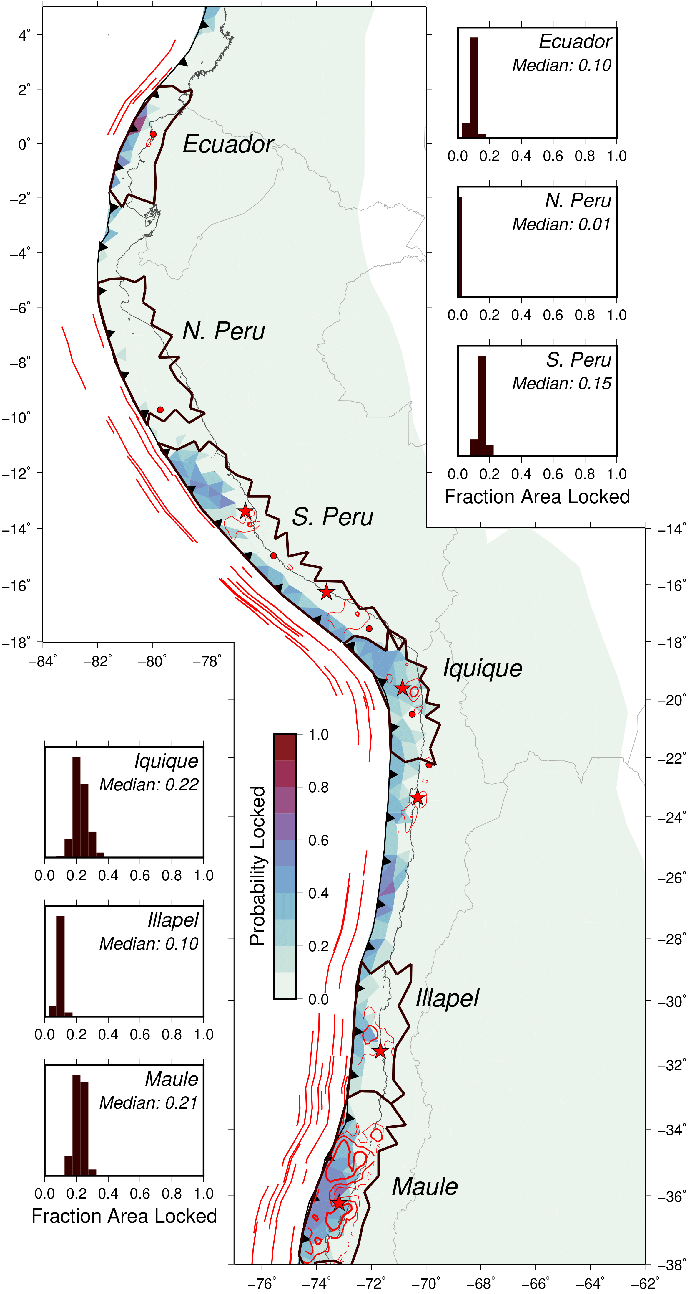 We are now using this conceptual understanding to actually map out which parts of the plate boundary are locked in between earthquakes, which parts are unlocked but accumulating potentially dangerous slip deficit, and which parts are totally unlocked and sliding at the convergence rate. We are examining the South America subduction zone as our case study, from Colombia to southern Chile. This subduction zone has a long historical record of earthquakes and there are over 600 GPS stations measuring the small motions caused by locking on the plate boundary. We combine these observations with our pseudo-coupling model to directly estimate the probability that different parts of the subduction plate boundary are locked. We can map the solution into slip deficit as well, giving us better constraints on the slip deficit in hard to measure places like near the subduction trench far offshore. Finally, we compare the inter-seismic locked sections with historical and recent earthquakes to understand the links between locking and earthquake rupture (Herman and Govers, 2020).
The next step is to apply these lessons to subduction zones globally. I hope to answer questions such as: Does this locking framework help anticipate great earthquake characteristics? How do subduction zones experience many magnitude 8 earthquakes and still build up enough slip deficit to have magnitude 9 or larger events? What controls seismic gaps (is it length, geometry, or something else)?
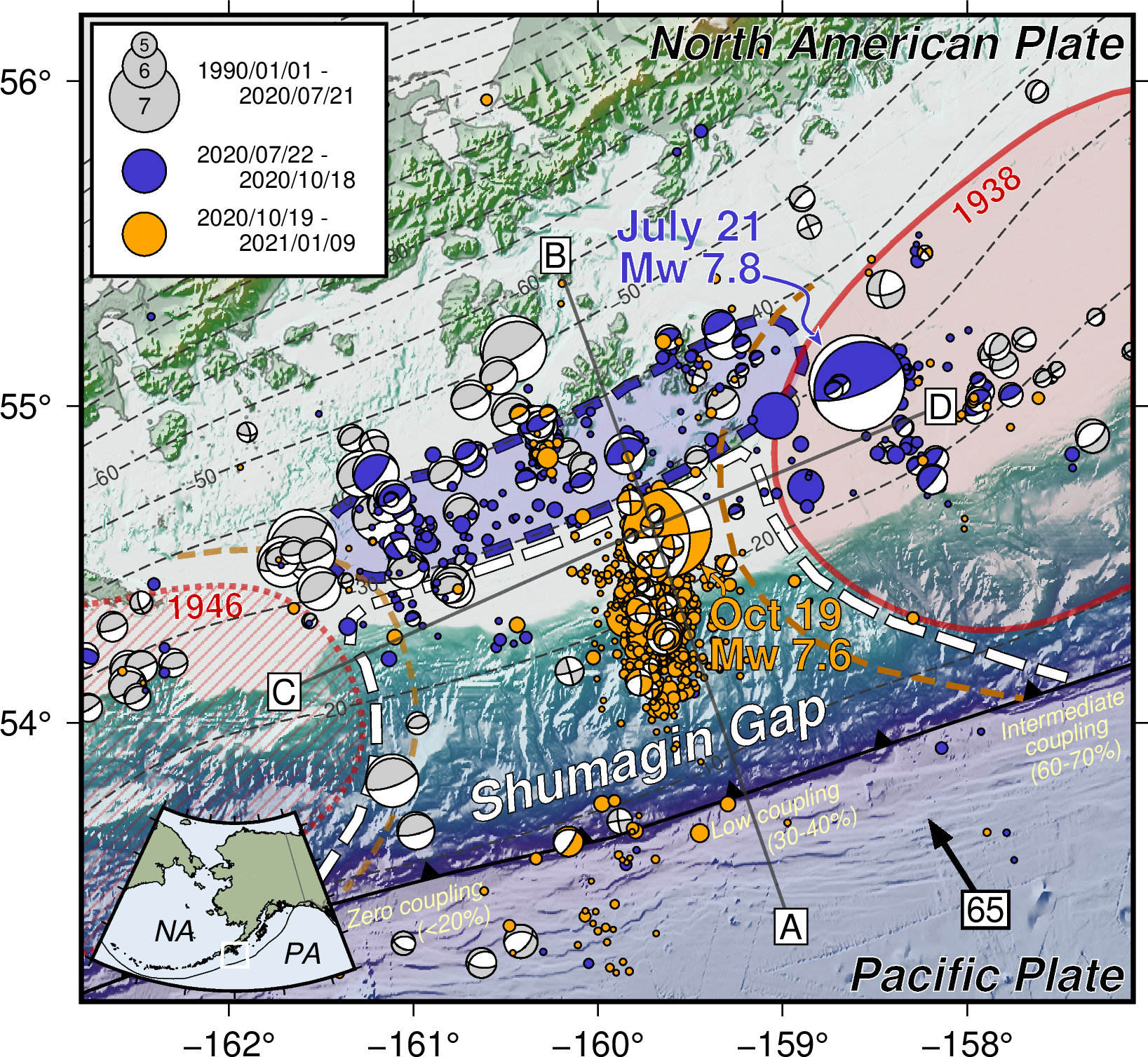 A surprising example of this pseudo-coupling framework was the 2020 Shumagin Islands earthquake sequence in the Alaska-Aleutian subduction zone (Herman and Furlong, 2021). The Shumagin Gap is a section of the plate boundary thought to be relatively uncoupled and incapable of hosting large plate interface earthquakes. On the east side of the Shumagin Gap is a coupled region that has hosted magnitude 8 and larger earthquakes historically, including a magnitude 8.2-8.4 event in 1938. This coupling configuration suggests that pseudo-coupling should be important in the Shumagin Gap.
On July 21, 2020, a magnitude 7.8 earthquake occurred near the coupled-uncoupled boundary. This event appears to have ruptured from the coupled region (showing "typical" seismic characteristics) into the region of greatest pseudo-coupling on the eastern edge of the Shumagin Gap (showing relatively aseismic slip here). By itself, this event was not particularly surprising. It triggered a series of aftershocks and afterslip down-dip of the Shumagin Gap, suggesting that the base of the Shumagin Gap can be seismic, even if the shallower section is not. More surprising was the magnitude 7.6 earthquake on October 19, 2020, which occurred in the gap. However, this event was not a plate boundary earthquake - it was a strike-slip earthquake within the subducting plate along a fault perpendicular to the trench. Our pseudo-coupling models of the stresses in the subducting slab suggest that this event was actually favored if the Shumagin Gap is uncoupled. Perhaps unexpectedly, the earthquake in the gap is evidence for low plate interface coupling!
Quantifying Geodynamic Forces
Collaborators: Rob Govers (Utrecht University), Nicolai Nijholt (UU, now at TU Delft), Lukas van der Wiel (UU)
 There is an ongoing discussion about the relative significance of various geodynamic drivers in many rapidly deforming regions around the world. Various approaches to this problem include elastic block models, where deformation is partitioned onto discrete faults; viscous sheet models, where gravitational potential energy variations play the most important role; and hybrid models, where many geodynamic forces — some well established, others newly proposed — are incorporated. The primary constraints on these models are (a) velocity observations measured at GNSS stations and increasingly by satellite radar interferometry, and (b) stress orientations constrained dominantly by earthquake focal mechanisms. A major question is whether these observations are capable of distinguishing between the various geodynamic models.
I am developing a technique to systematically and quantitatively answer this question. With Nicolai Nijholt and Rob Govers, we have been developing 2-D finite element models of the Gibraltar and Aegean regions, which include major faults, subduction-related forces, other gravitational forces, and plate motion drivers. But to answer our research question, it is not sufficient to run just this one model anymore! To determine which of these forces can be constrained, we run 10s or 100s of thousands of these models, varying the parameters to see which produces the best fit. (For aficianados out there, we are using a Bayesian framework.)
Extension in Subduction Zones After Megathrust Earthquakes
Collaborators: Rob Govers (Utrecht University), Kevin Furlong (Penn State University)
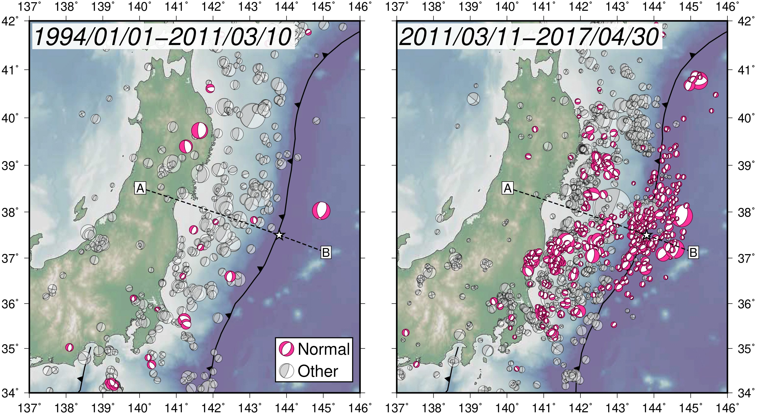 The maps at the left show the substantial increase in normal faulting earthquakes after the 2011 Mw 9.0 Tohoku, Japan, earthquake. Although there were some normal faulting earthquakes prior to 2011, they were relatively infrequent and accounted for a small percentage of the total moment release. An important question for constraining seismic hazards and understanding the nature of earthquake cycle deformation processes is how long these extensional events will continue. We examine these events in context of relatively straightforward geodynamic earthquake cycle models representing the Japan subduction zone, and compare these model results to instances of normal faulting earthquakes triggered by large megathrust earthquakes globally.
This analysis shows that great megathrust earthquakes and triggered afterslip on the plate boundary promote normal faulting earthquakes, but the location and intensity of these aftershocks depends strongly on the spatial distribution and magnitude of co-seismic slip. Viscous relaxation of the deeper, warmer asthenosphere does little to the stress state of the elastic regions. Therefore, the system remains in a state favorable for normal faulting events until relocking of the plate interface and continued plate motion gradually re-establish the pre-earthquake compression. It turns out an important aspect of the stress evolution in the system is the degree of locking in the seismogenic sections of the plate interface. If the interface is widely locked, it is more difficult to trigger normal faulting seismicity. If instead the interface is characterized by locked patches, then extensional deformation is easier to produce. These two scenarios are hard to distinguish from direct observations, though, because they produce similar fault slip and surface deformation due to the pseudo-coupling effect (Herman and Govers, 2020).
Earthquake History and Records of Locking
Collaborators: Rob Govers (Utrecht University), Mario D'Acquisto (UU)
The inter-seismic slip deficit accumulation rate on the subduction plate interface due to frictional locking is a key parameter in estimating the hazard posed by large magnitude megathrust earthquakes. Geodetic observations of surface motions in between large events are typically used to estimate the slip deficit accumulation rate; however, these datasets also record other deformation processes, such as apparent partial coupling, afterslip, and viscous relaxation. The surface motions produced by these processes overlap with the signal produced by locked asperities and may therefore bias interpretations of the slip deficit on the plate interface. We already demonstrated in a previous modeling study how partial slip deficit accumulates in the regions between fully locked asperities. Next, we want to use 3D geodynamic models to quantify how motions associated with post-seismic afterslip and viscous relaxation affect the ability to resolve this distribution of (partial) coupling on the megathrust.
We find that earthquakes under a threshold magnitude (Mw ~6.5-7.0), produce essentially negligible post-seismic surface displacements compared to the locking signal. As the magnitude of the event increases, its post-seismic effects overprint the coupling signal over a larger area and for a longer time. We use the central Chile subduction zone (which includes the 2010 Mw 8.8 Maule and 2015 Mw 8.3 Illapel events) as a case study, modeling inter-seismic loading as well as the co- and post-seismic effects of earthquakes dating back to the 19th century. Irrespective of magnitude, no event prior to 1900 has an effect on modern surface observations, whereas great (Mw 8.0+) earthquakes in the past ~50 years are still associated with reduced landward velocities relative to the full locking velocity. Near the rupture zones of the 2010 Maule and 2015 Illapel earthquakes, post-seismic motion currently produces oceanward surface velocities, which may not reflect the locking signal for several decades (Herman et al., in preparation).
Seismotectonics of Thailand and Vicinity
Collaborators: Kevin Furlong (Penn State University), Passakorn Pananont (Kasetsart University), Beth Meyers (PSU), Patinya Pornsopin (KU, Thai Meteorological Department)
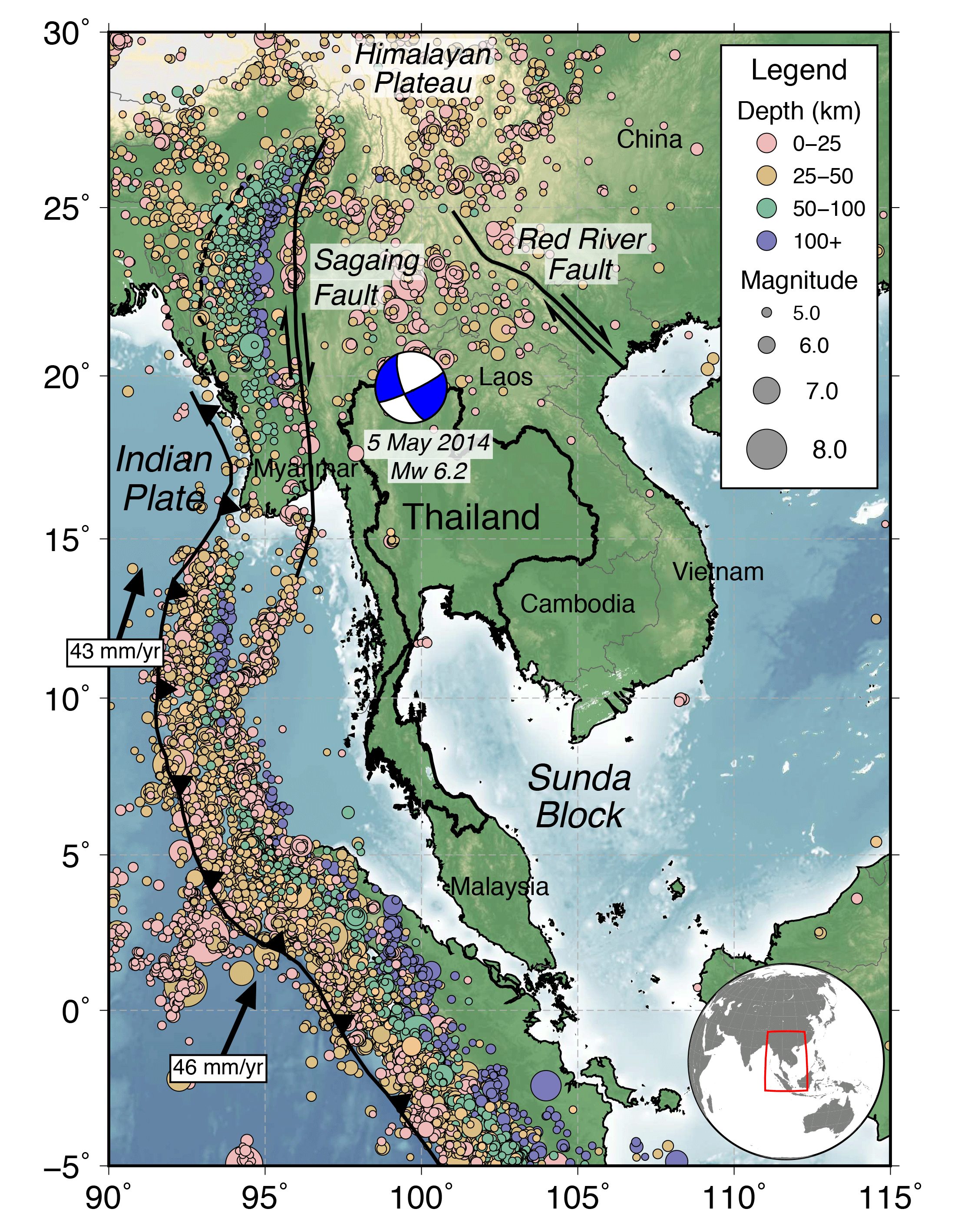 Southeast Asia lies between two distinctive convergent plate boundaries: the Indonesian subduction zone to the south and the Himalayan continental collision zone to the northwest. Hazards posed by earthquakes occurring along these plate boundaries pose a major risk to countries in Southeast Asia, including Thailand. In addition, there are several active faults within Thailand itself, which have either had significant historical earthquakes or show geological evidence of seismic activity. I collaborate with colleagues at Kasetsart University in Bangkok to observe and interpret patterns of recent earthquakes in the region (Pananont et al., 2014).
We are now beginning to develop numerical models of the geodynamic processes responsible for earthquakes throughout Southeast Asia (such as the preliminary models published in Meyers et al., 2018). Through these studies, we will answer such questions as:
- What is the role of the Sumatra-Andaman subduction zone in driving deformation throughout the rest of Southeast Asia?
- How do major fault structures partition the surface motions and the corresponding stresses?
- What is the relative importance of plate interactions and forces associated with geological heterogeneity in generating the stress field throughout the region?
Filling Gaps - The 2014 Iquique and 2015 Illapel Earthquakes
Collaborators: Kevin Furlong (Penn State University), Gavin Hayes (USGS National Earthquake Information Center), Harley Benz (NEIC), William Yeck (NEIC), Jennifer Nealy (NEIC), William Barnhart (University of Iowa)
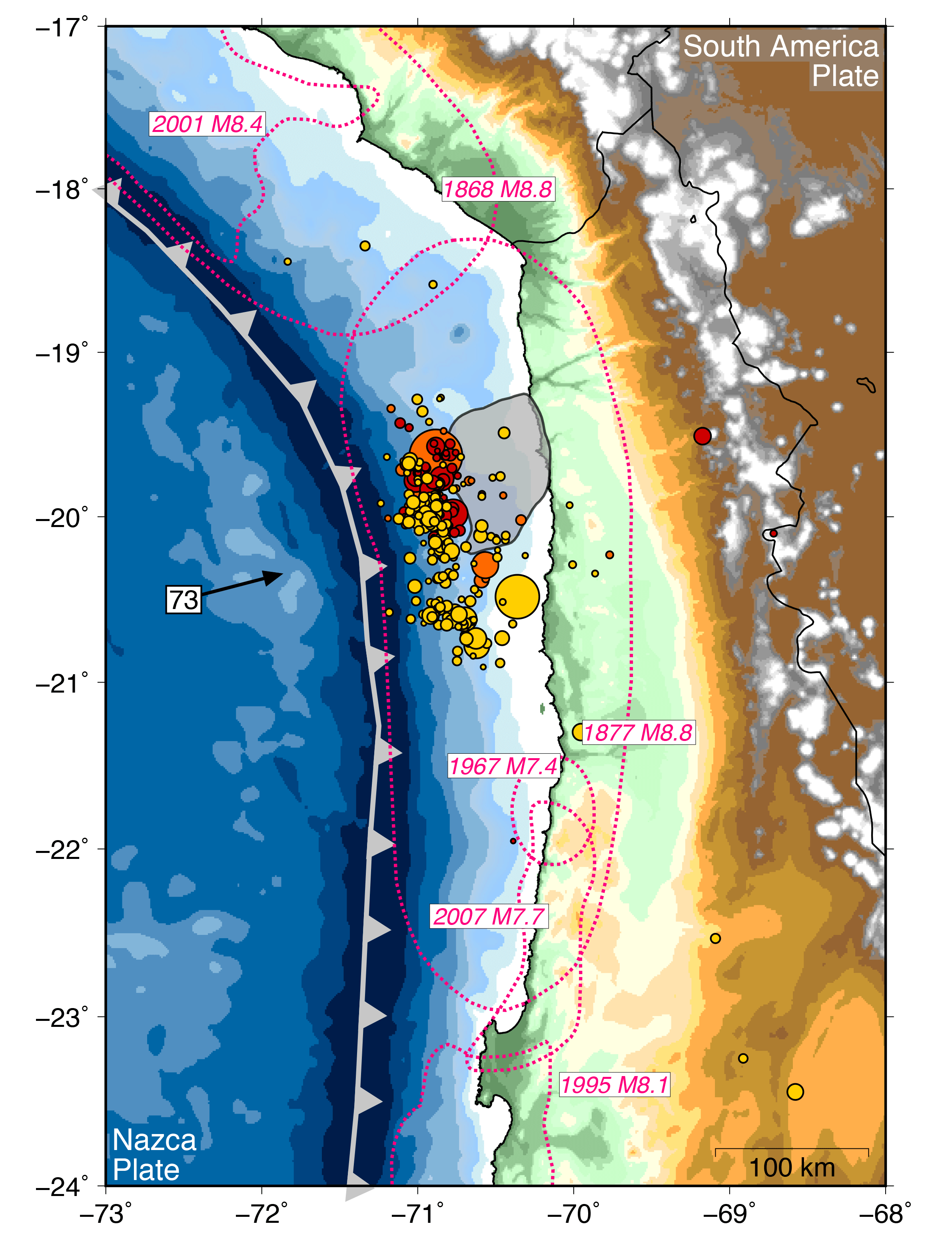 The oceanic Nazca plate descends eastward under South America at 70 mm/yr along the subduction trench that lies parallel to the coast of Chile. This subduction zone has a long history of hosting large earthquakes that produce severe shaking and extensive tsunamis. Some parts of the boundary last experienced a great (magnitude 8 or larger) earthquake over a century ago. Enough time has passed that these "seismic gaps" represent a significant great earthquake and tsunami hazard. I studied two events that ruptured seismic gaps in the Chilean subduction zone in detail, examining the processes that led up to the mainshocks, the characteristics of mainshock slip and aftershock distributions, and the possibility for future earthquakes.
On April 1, 2014, a magnitude 8.2 megathrust earthquake occurred offshore of northern Chile, generating severe shaking and producing a 2 meter tsunami in the Port of Iquique. This earthquake was preceded by four magnitude 6.0 and larger foreshocks in the two weeks before the big one. Should we have seen it coming? I used a technique called Coulomb stress change analysis to determine that these events may have sequentially triggered each other and led to the mainshock. I also carefully examined records of slow ground motion in Chile before the earthquake, as measured by high-precision GPS instruments. The GPS data suggest that there was other slip on the plate boundary during the foreshock sequence that did not produce large earthquakes, but may have aided in triggering the mainshock (Herman et al., 2016).
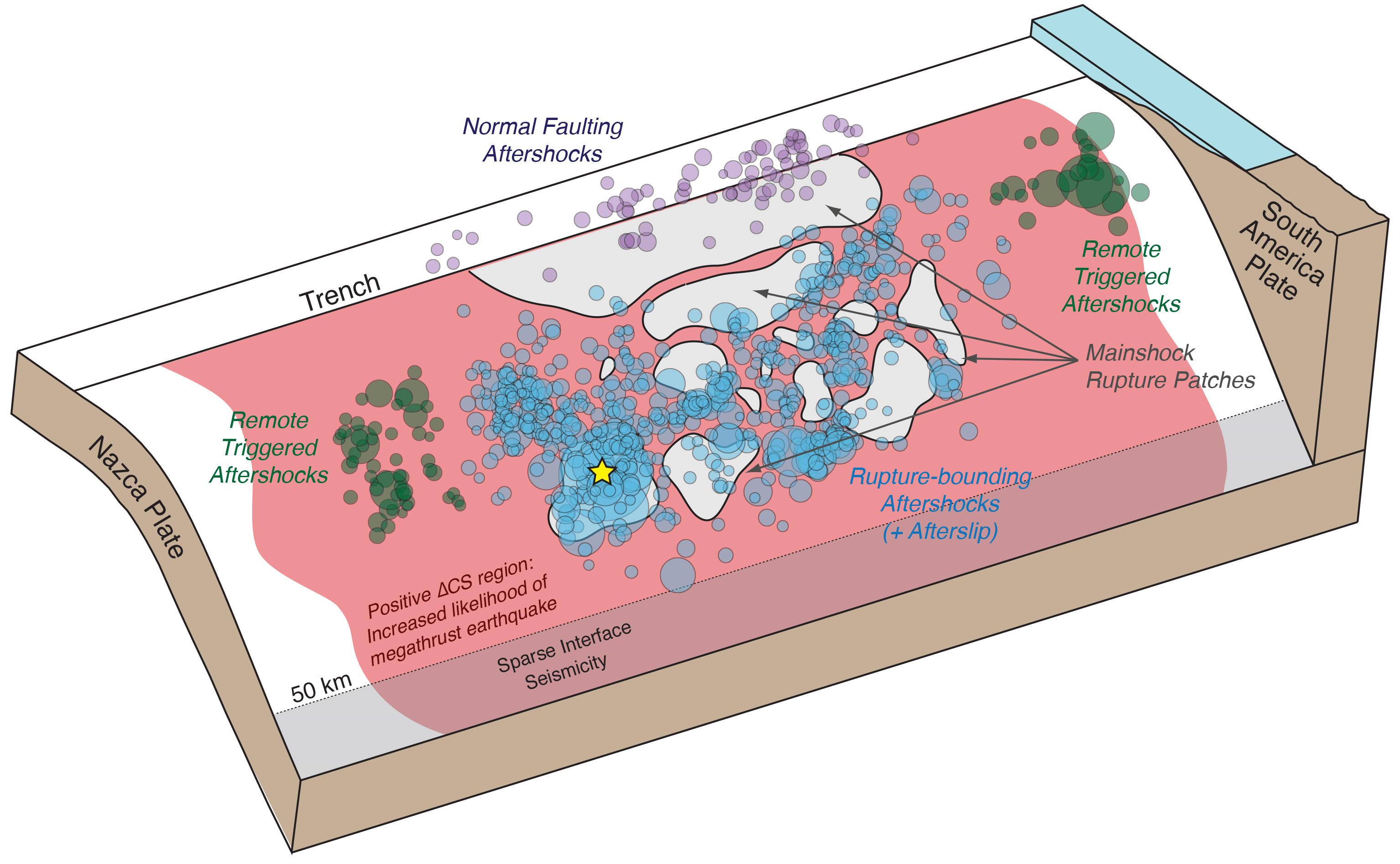 The 2015 Mw 8.3 Illapel, Chile, earthquake occurred in another seismic gap in the Chilean subduction zone. The ability to record and describe earthquake locations and sizes has improved by a huge amount over the past decade. For this event, I led a collaborative effort with scientists at the USGS and University of Iowa to combine and integrate results from different types of observations and improve our understanding more than the individual analytical techniques. The details of co-seismic slip during the earthquake, careful and precise aftershock locations, and physical models of the deformation in the subduction system suggest that the most vigorous aftershock activity occurs near the edges of the rupture zone and decays relatively quickly. The location and distribution of these aftershocks are highly sensitive to the location and magnitude of slip. In contrast, triggered events continue to occur farther from the rupture zone over a much longer time period. These events include both aftershocks on the interface, as well as other events, such as outer rise aftershocks occurring primarily next to areas where slip came closest to the trench (Herman et al., 2017).
Are Earthquakes Different Far From Plate Boundaries? The 2010-2016 Canterbury Earthquake Sequence
Collaborators: Kevin Furlong (Penn State University), Robert Herrmann (Saint Louis University), Harley Benz (USGS National Earthquake Information Center)
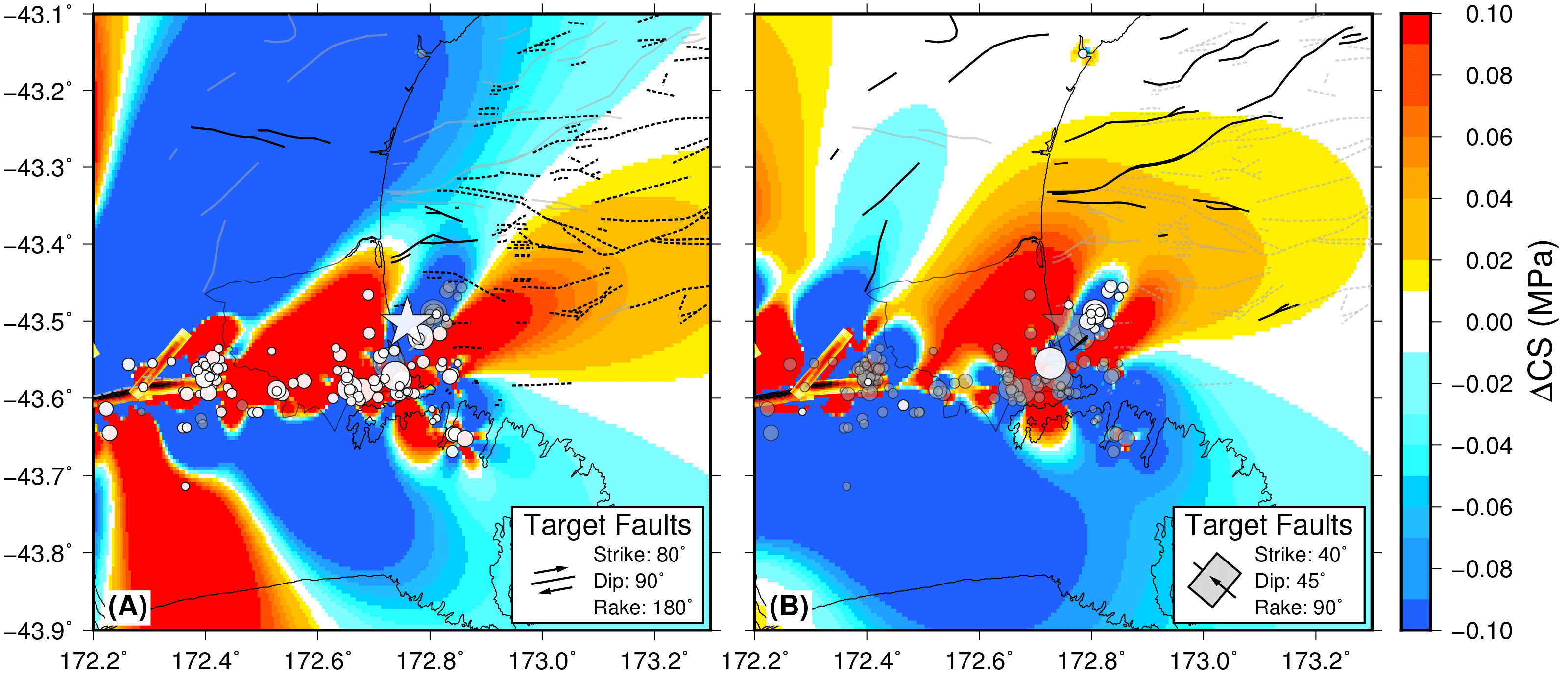
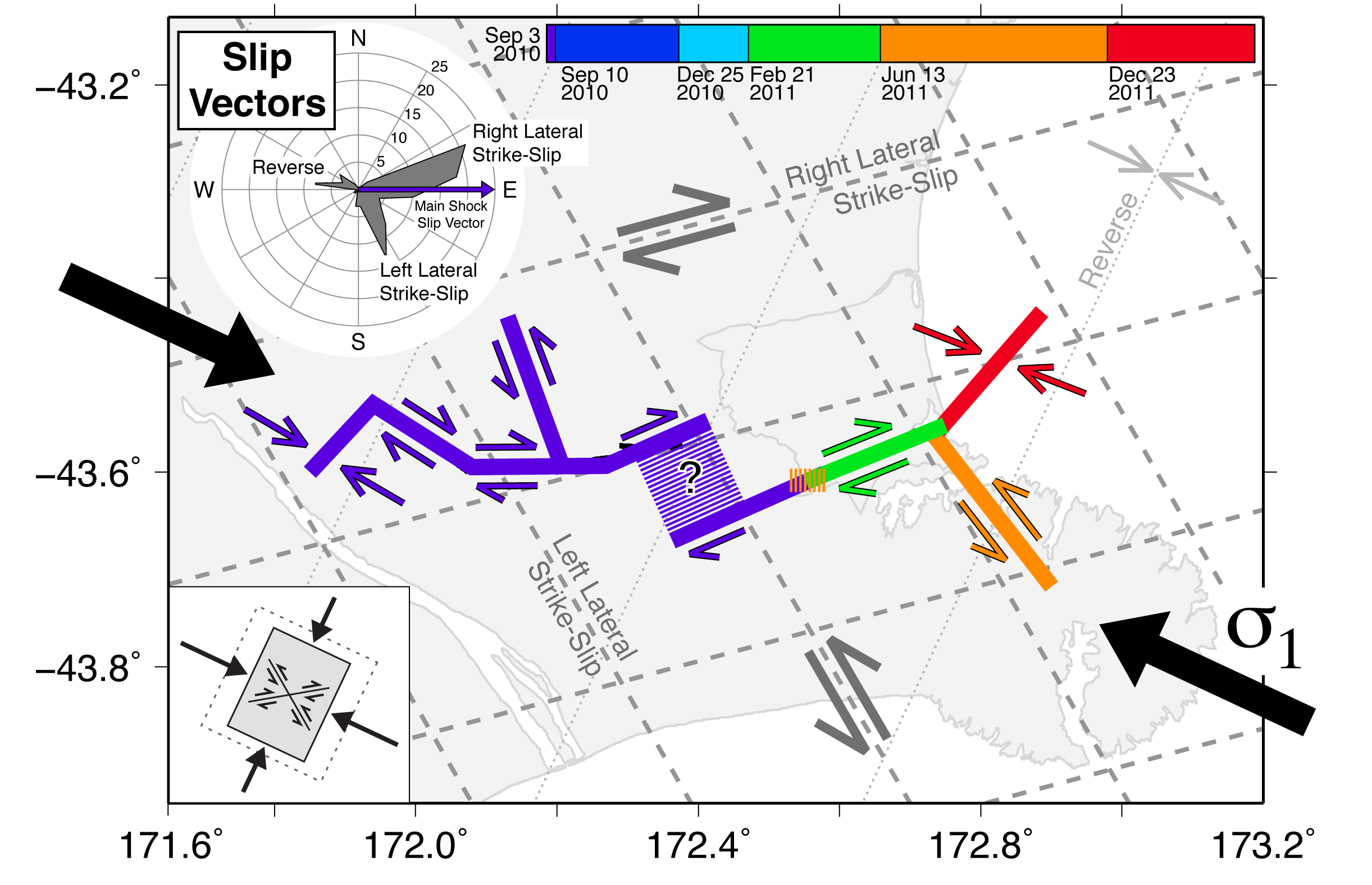 In September 2010, a magnitude 7.0 earthquake struck in the region west of Christchurch on the South Island of New Zealand. Although the South Island of New Zealand straddles the boundary between the Pacific and Australia plates, the earthquake source region is far from the plate boundary and has been notably devoid of seismicity over the last century. The September event was followed over the next two years by a sequence of over 10,000 aftershocks, including a deadly magnitude 6.1 earthquake beneath Christchurch in February 2011, another magnitude 5.8 event in June 2011, and a pair of magnitude 5.8 aftershocks in December 2011. An important question in the seismic hazard assessment of such low-seismicity areas is whether the behavior of this sequence can be understood through the same lens as more common plate boundary seismicity (like that of California, Turkey, or the Alpine Fault of New Zealand). To address this issue, I performed different types of seismological analyses on 150 of the largest earthquakes in the sequence to figure out how the faults slipped from the records of shaking. Perhaps our most important finding is that these earthquakes relieved stresses locally, but the broader region of eastern South Island still remains in the same state of stress that is responsible for these earthquakes (Herman et al., 2014).
 Seismicity in South Island, New Zealand, also continued to occur for a much longer time period than is typically expected. One common way to think about the duration of an aftershock sequence is by looking how aftershock frequency decreases over time, which is typically proportional to 1/time (this is called "Omori's Law"). But this "Law" is really an empirical relation; there are no physics dictating that the aftershock rate must decrease in this fashion. In reality, stress changes from earlier earthquakes might trigger subsequent large earthquakes long after the aftershocks from the initial event should have decayed according to Omori's Law. Then these subsequent earthquakes will have decaying aftershock sequences of their own. I explored the seismological details of another magnitude 5.7 earthquake in Christchurch, New Zealand, which occurred in 2016, years after the last major event from the earlier Canterbury earthquake sequence. I used this earthquake to bring attention to other nearby areas that may still represent a seismic hazard in the Christchurch region (Herman and Furlong, 2016).